|
Civil and Environmental Engineering Earth and Environmental Sciences University of Waterloo |
|
|
Dynamics of Hormone Loads and Attenuation in Ditches and Streams Passive Surface Water Flux Meter (PSFM) Hydrologic Connectivity of Drained (Farmed) Wetlands in Iowa’s Prairie Pothole Landscape Hydrologic Impacts of Artificial Drainage Remote Sensing Based Distributed Hydrologic Modeling |
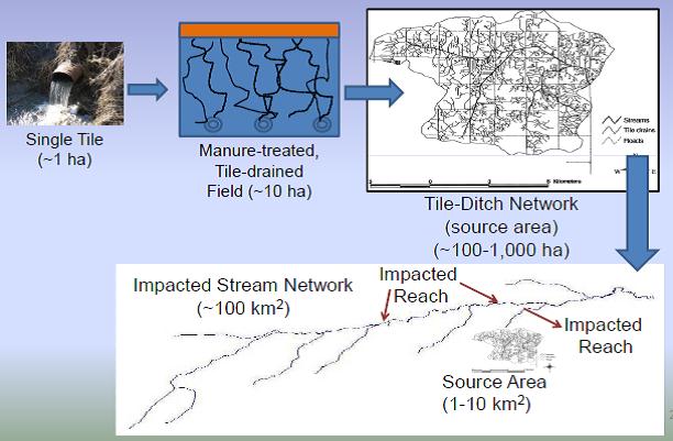
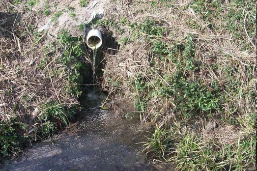
Monsoon Harvests:Dynamics of Hormone Loads and Attenuation in Ditches and StreamsThis is a collaborative project between Purdue University and University of Iowa, and funded by USDA, to study the environmental fate and transport of synthetic and natural hormones from land application of animal manures generated by concentrated animal feeding operations (CAFOs). Concentrations of hormones sufficient to invoke impacts on aquatic species
(3) Assess in-stream biogeochemical processes attenuating hormones during transport; and (4) Predict and validate what hormone loads will be transported in the stream network beyond the source area. Passive Surface Water Flux Meter (PSFM)Much research in watersheds is aimed at describing spatially distributed processes while telescoping monitoring efforts towards a single point of interest, the watershed outlet. Developing spatially distributed models that are calibrated against such spatially integrated measurements often leads to equifinality and non-uniqueness issues.
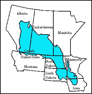
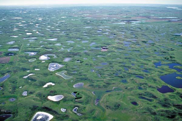
Hydrologic Connectivity of Drained (Farmed) Wetlands in Iowa’s Prairie Pothole LandscapeThe Prairie Pothole Region (PPR) is a vast area of glacially formed depressional wetlands that extends from Alberta to Minnesota, with the southern tip reaching into Iowa (Figure 1). The portion of the PPR that extends into Iowa is known as the Des Moines Lobe and covers an area of 3.5 million ha.
Hydrologic Impacts of Artificial DrainageFollowing recent flooding, there has been renewed discussion regarding the impacts of drainage, specifically tile drainage, on streamflow hydrology. Due to the importance of drainage systems to agricultural productivity in Iowa there is a need to conduct a comprehensive assessment of the hydrologic impacts of drainage systems.
People, Water and Climate: Adaptation and Resilience in Agricultural WatershedsThis is a collaborative project between University of Iowa, Iowa State University and the Southern Illinois University, and funded by NSF Coupled Natural and Human Systems Program. The overall objective of this project is to develop a better understanding of the processes that link global-scale climate and socioeconomic drivers to regional-scale responses in land use decision making, water quality, and water quantity. We are currently hiring Masters and PhD level students on this project.Remote Sensing Based Distributed Hydrologic Modeling in Midwestern Landscapes for Predicting “Tile-to-Tide” ResponsesIn this project, funded by the Center for Global, Regional and Environmental Research (CGRER), we are exploring the use of remote sensing (RS) products (MODIS) for developing parsimonious hydrologic models that can then be used in conjunction with water quality modules to evaluate impacts of dynamic land-use shifts under alternate energy production scenarios. The Threshold Exceedance Lagrangian Model (TELM) developed by Basu et al (2010) is unique in its ability to identify functionally homogeneous units in the watershed, and predict streamflow, without calibration, using hydrologic attributes specific to tile-drained Midwestern watersheds. Our overall objective is to enhance the parsimonious hydrologic model TELM by using remotely sensed vegetation data. The model RS-TELM will then be used for prediction of spatially distributed runoff patterns in watersheds across the state of Iowa. |